From a neighbourMartin Opatrný, farm near Plánice

See what is happening on your fields.

Rain, field work weather and crop changes for each of your fields. Built in the Czech Republic, with a crop stage model that transfers between countries.

Open the sample farmContact Martin
Czech farm? Search by IČO

IČO is the 8-digit Czech company ID. Samples are ready only for Czech farms so far.

Viewing a sample commits you to nothing.

Field overview from my farm

Sample from my own farm, built on 22 November 2026 05:45

This sample is a snapshot from the time shown. Time-sensitive figures appear after their freshness is verified.

No change

The satellite reports nothing to check

My farm near Plánice: 9 fields, 24 ha, mainly meadows and pastures and orchards. On the image from 5 November 2026, the crop has not thinned noticeably on any of the 8 largest fields. I use it myself.

Aerial image of Martin Opatrný's fields near Plánice, outlines of 9 fields in white

my fields (9)

ČHMÚ radar, live

Rain in the next hour

The ČHMÚ radar shows whether it is raining at the farm and whether rain is coming.

On one screen: radar, weather forecast and satellite. We add your soil sensors and Helios after a technical check.

See the full overview of my farm Image © ČÚZK, other sources below
Right now on my farmLoading the reading for my farm.Open the live sample

We work with open data

  • ČHMÚ
  • Copernicus Sentinel
  • Czech Ministry of Agriculture
  • ČÚZK

A real sample

This is my field overview.

My own farm, real data. Open the overview on your phone too.

211farms already have a sample ready
9fields on my farm near Plánice
24 haof land in the sample
3 daysof forecast for field work
Open the overview of my farm

What you will see

See field changes straight away.

Two satellite images of the same field side by side. When the crop weakens, the overview flags it.

Satellite images of one field
No change

Field 3701/4 (5.2 ha, meadow or pasture): the crop is holding, nothing to check
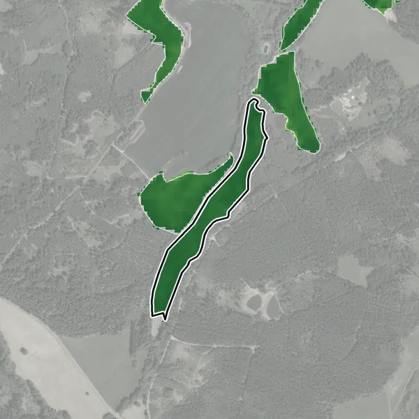
Satellite image of field 3701/4 from 8 June 2026: the darker the green, the denser the crop
8. 6. 2026
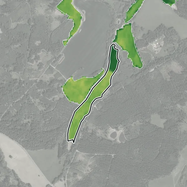
Satellite image of field 3701/4 from 21 June 2026: the darker the green, the denser the crop
21. 6. 2026
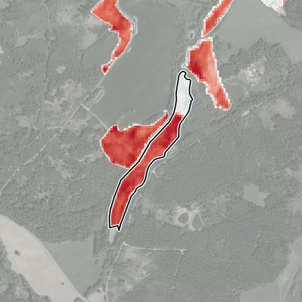
Change in green on field 3701/4 between 8 June 2026 and 21 June 2026, decrease in red
Changedecrease in red

bare soildense crop

decreaseincrease

This is what a change looks like when the satellite picks it up: between the images from 8 June 2026 and 21 June 2026, this field lost a lot of green. On a meadow this is usually mowing, but the satellite does not know the cause.

Satellite now: no notable change, nothing to check

There is no notable change here.

Overview of my farm as of 22 November 2026: nothing to check on 9 fields. Images: Copernicus Sentinel (2026), aerial image © ČÚZK.

Technical details

Sentinel-2 measures crop green with the NDVI index (0 is bare soil, 1 a dense green crop). Change shown: 0.83 on the image from 8 June 2026 and 0.53 on the image from 21 June 2026. An alert is raised for a marked drop against the previous image or against surrounding fields with the same land use.

Weather for field work for 3 days and a soil moisture estimate

Fertiliser records download as a table. Morning alerts and eAGRI export (Czech farm portal) are coming.

Open the sample farm

ČHMÚ, the Czech weather service

ČHMÚ weather for your fields.

Where it rains, where the rain is heading and which warnings apply to you, with the time of issue.

Live from ČHMÚ

Loading the ČHMÚ radar

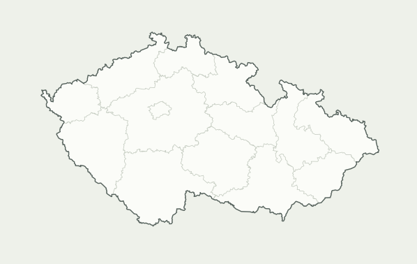
Map of the Czech Republic with regional borders
Measured every 5 minutes, replay of the last hour and an outlook for the next one. ČHMÚ, CC BY 4.0, cropped.
What the radar and forecast can do
  • Hourly forecast for 3 days

    The ČHMÚ forecast for your fields, not for the nearest town: rain, temperature and wind hour by hour, always with the time of the latest run. It is also used for the spraying window and the irrigation plan.

  • Radar: where it is raining now

    Where it is raining now and how hard, right over your fields. The radar updates every 5 minutes.

  • One-hour rain outlook

    An estimate of where the rain the radar already sees will move within an hour. It does not predict new storms, and the radar captures hail or light rain only roughly.

  • ČHMÚ warnings for your fields

    Current warnings for the administrative district where the fields lie, including drought warnings.

Technical details about the ČHMÚ data

The forecast is the ČHMÚ ALADIN model with a 1 km grid and a new run four times a day; in a farm's overview, each area also shows the yr.no (MET Norway) forecast. The radar is the ČHMÚ composite (PseudoCAPPI 2 km, an image every 5 minutes), and rain intensity is an estimate in millimetres per hour using the Marshall-Palmer relation. The one-hour outlook moves the rain the radar already sees (nowcasting). Warnings are in CAP format, district borders come from RÚIAN (the Czech register of territorial identification).

Source: ČHMÚ, licence CC BY 4.0, modified. Both radar and forecast are estimates.

Getting started

Your fields, land rent and partnerships.

Try the farm overview and calculator for free. We are preparing a one-off paid report for landowners and data integration for businesses.

Explore without obligation

Your field overview

Open prepared fields by company ID, or explore my own farm right away.

Show my fields

In preparation: CZK 299 including VAT

Land rent report for discussions

Start with a free calculation for your parcels. The paid document and spreadsheet will preserve the result, comparisons and sources for further discussions.

Calculate land rent for free

For businesses and developers

Data for your application

Field overviews and alerts for an existing system. A public demo is ready for businesses and developers.

Partnership options
Weather stations and integration with your operation

Connections

We link what you have.

No new sensors, and you keep Helios (Czech accounting software) or your current system. You connect your own weather station yourself, right away; Helios and soil sensors follow after a technical check.

Weather station, Helios, soil sensors and how connecting works
Connect it yourself

Your weather station

Ecowitt, Froggit, Bresser, Sainlogic and other stations that can upload to a custom server. Enter the address and code in the station app and data arrives within minutes. Netatmo and Davis we connect together.

Every morning you see the night minimum next to the nearest ČHMÚ (Czech met service) station. In a hollow or an orchard, clear nights are often several degrees colder.

Connect a weather station Frost exposure of your orchards
Only once connected

Helios: read only

Depending on the version, either from a spreadsheet that Helios can save or directly through its interface (Helios iNuvio and Nephrite have one, for example). For Helios Orange and older versions, it depends on what your administrator allows. We do not write or change anything in Helios.

You then see, for example, work or costs for a field, once we agree how the field is labelled in Helios.

Only once connected

The soil sensors you already have

Pessl (METOS, FieldClimate), Sencrop, Sentek, METER (ZENTRA) and others. We take the data directly from the sensor maker, or from a spreadsheet the sensor can save.

For each field, a chart of soil moisture by depth next to our estimate from the weather (rain minus evaporation). A person decides on irrigation: we show what the sensor says and what the estimate says.

How connecting works

  1. A short call: what you use and what you want to see for a field.
  2. Technical check: with your Helios administrator and sensor supplier, we check what your version and sensors allow.
  3. A sample with your data from a spreadsheet, still without a permanent connection.
  4. Connection once the scope is agreed.
What we will need from you

What we will need from you

  • the name and version of Helios (the About window) and your administrator's contact,
  • a sample spreadsheet from Helios without sensitive data, for example work or costs,
  • the make and type of the sensors, the measuring depths and how you get the data today,
  • consent to read-only access.

Do not send passwords by e-mail. We arrange a technical account with your administrator. Where the data are stored and who can access them is set out in the contract.

No finished Helios or sensor connection in the sample yet. We connect them after a technical check.

Notes from your phone

Notes straight from the field.

A field photo and note on your phone. Demo notes stay in your browser.

How notes work and where they stay
  • note status: fine, check, or task,
  • the photo is saved at a smaller size so it does not take up space,
  • nothing to install, a browser on your phone is enough.

In the sample, notes stay only on your phone and are not sent anywhere. If you delete your browser data, the notes are deleted too. Sharing notes within the farm and tasks for colleagues are in preparation.

Sample note from a phone

New note

Field
3701/4, 5.2 ha by location
When
today 8:40

Molehills, check in a week.

FineCheckTask

Save note

Sample form with a made-up note

Where the data come from

Every figure has a source.

Sources, calculations and checks on the ground

Source data

Public sources, each with the date it applies to. In the sample of my farm:

  • LPIS fields (Czech land parcel register) (Czech Ministry of Agriculture): downloaded 26 September 2026
  • Sentinel-2 satellite images (Copernicus): latest usable one from 5 November 2026 (newer passes up to 15 November 2026 were cloudy over the fields)
  • ČHMÚ measured rainfall: Lovčice, Kvasetice, daily totals up to 20 November 2026, today up to 22 November 2026 04:50
  • ČHMÚ ALADIN forecast: run of 22 November 2026 01:00
  • MET Norway forecast: 22. 11. 2026 02:17
  • ČHMÚ radar and warnings: live, every time the page opens
  • ECMWF rain probability: run of 21 November 2026 13:00
  • ERA5 soil moisture (Copernicus) to check the estimate: up to 15 November 2026

Other figures are from the sample of my farm as of 22 November 2026 05:45. The demo data is valid as of the time shown.

Estimate

From the source data we calculate:

  • the water stored in the soil for each field, that is the water balance (rain minus crop evaporation),
  • possible spraying windows from the forecast and general rules for wind, temperature, humidity and rain,
  • the probability of heavier daily rain from the ECMWF forecast.

In the sample, estimates show their certainty and how they were calculated.

Checks on the ground

Neither the satellite nor the model sees everything. On the field you check:

  • why the crop changed on the image (harvest, tillage, damage, drought),
  • how much water is really in the soil (probe, spade),
  • the conditions on the product label, which always takes precedence.

The full list of sources and their licences is in the questions below and in the page footer.

Martin Opatrný
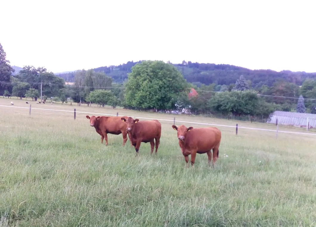
Our cows on pasture near Plánice
The U Opatrných farm near Plánice

Who is behind it

Martin Opatrný, farm near Plánice.

My family farms near Plánice, and I develop Agropočasí for the Czech University of Life Sciences. I build Opatrné pole on my own and use it on my farm.

My farm and working with you
  • The sample is my own farm

    The overview at the top of the page shows my fields near Plánice (9 fields, 24 ha, mainly meadows and pastures and orchards). No one else's data, I use it myself.

  • You deal with me directly

    We go through what you need to monitor and record.

  • Adjustments for your farm

    We check options for connecting to terminals, accounting or eAGRI based on the available interfaces.

Call +420 721 611 816

Questions and contact

Common questions.

Read answers to frequently asked questions
What happens when I enter an IČO?

If I have fields ready for your farm, you open them straight away: your land on a map, satellite images and, with a finished overview, water and weather for field work too. If they are not ready, leave me your phone number or e-mail. I will prepare them and get in touch. Samples are ready only for Czech farms so far.

Where does my sample come from?

The sample at the top of the page is my own farm near Plánice, not someone else's business. Samples for other farms are made from publicly available fields in LPIS (the Czech land parcel register, by registered user) and Sentinel 2 images; other sources are listed above. We did not need your internal records for the basic sample.

We mark samples with a noindex tag so that search engines do not show them. This is not access protection: anyone who knows the link can open it, and a sample can be found by IČO. To have a sample removed, write to [email protected].

What happens to my data?

I use the contact details from the form to handle your enquiry. Technical data may be used to protect the form. Details are in the privacy policy (in Czech).

In the samples, your test notes stay only in your browser and are not sent to the server. Terms for handling records, export and ending the service are set out in the contract.

Where do you get the data?

We list the sources and their terms of use here. We use public sources whose terms of use we have checked and which do not exclude commercial use:

  • fields of land blocks: LPIS, Czech Ministry of Agriculture (open data in the National Catalogue, free of copyright and database rights),
  • crop condition: Sentinel 2 satellites of the Copernicus programme (Copernicus terms),
  • satellite check: Sentinel 1, for checking only, not used in recommendations,
  • evaporation and soil moisture: ERA5 reanalysis, Copernicus Climate Change Service, accessed through the public Google ARCO copy (CC BY 4.0),
  • measured rainfall and temperatures: ČHMÚ open data (CC BY 4.0),
  • radar, radar outlook, warnings and the ALADIN forecast: ČHMÚ open data (CC BY 4.0), we do not use lightning data (it comes from a commercial network),
  • district borders for warnings: RÚIAN, ČÚZK (CC BY 4.0),
  • rain probability: ECMWF open data (CC BY 4.0),
  • weather forecast: MET Norway (CC BY 4.0),
  • BPEJ soil units: Czech State Land Office (CC0),
  • orthophoto: ČÚZK (the Czech Office for Surveying, Mapping and Cadastre) (CC BY 4.0).

We do not use any data or code from Agropočasí.

How accurate is the irrigation advice?

It is an estimate from the water balance (rain minus crop evaporation) compared with the satellite. The result depends on the available data and on assumptions about the soil and the crop, so check it on the ground. We want to show the basis and the limits of every recommendation. We want to validate the model with participating farms on their real data.

The sample assesses the weather for field work, not the choice of product or its dose. The registration and the label apply.

Does it work with eAGRI?

In the samples, you can download fertiliser records as a spreadsheet (CSV) for checking. A direct export in the eAGRI format (the Czech Ministry of Agriculture's online portal) is in preparation, and before launching it we will check the format and the required fields.

Until then, the CSV is only a working document, not a verified submission format. Submitting to eAGRI remains your responsibility.

What do you need for it?

Just a browser. You open the sample on a computer or a phone, nothing to install.

Call me or write to me.

We agree on what you need to monitor on your fields.

Call +420 721 611 816
  • [email protected]
  • Ing. Martin Opatrný, U Opatrných farm near Plánice, Klatovy district, Czech Republic

Write a message